Home » Voice Solutions » Mobile Video Solutions » UAV Management Platforms

Unmanned Aerial Systems (UAS) are revolutionizing public safety, emergency response, and critical infrastructure monitoring by delivering unmatched situational awareness, operational efficiency, and evidence collection capabilities. At MCA, we provide advanced aerial video solutions powered by the Motorola Cape suite of applications, tailored to the needs of law enforcement, fire, and rescue departments, as well as national utilities in the electric, power, oil, and gas sectors.
From monitoring large-scale incidents and conducting search and rescue missions to inspecting critical infrastructure and capturing actionable data, our drone and UAV systems offer real-time insights that enhance decision-making and operational safety. MCA’s solutions include state-of-the-art aerial video platforms, seamless integration with Motorola’s ecosystem, and secure data management tools, empowering agencies and industries to protect their assets, improve response times, and ensure mission success.
MCA delivers advanced aerial video solutions designed to elevate situational awareness and operational efficiency for public safety agencies and critical infrastructure industries. Our offerings include high-performance drones and UAV systems for superior data capture and Motorola’s Cape software suite, featuring tools for seamless piloting, viewing, and command operations. These solutions enable safe, confident field operations, real-time multi-agency collaboration, and centralized oversight for mission-critical success.
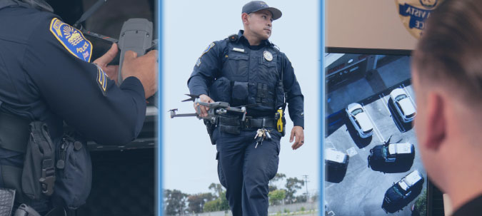
The Motorola CAPE Suite revolutionizes aerial video solutions with a comprehensive software platform designed for drones and UAV systems. Featuring three key components—CAPE Pilot for field operations, CAPE Command for centralized oversight, and CAPE Watch for real-time collaboration—it empowers public safety agencies and critical infrastructure teams to enhance situational awareness, streamline operations, and ensure safety.

The CAPE Aerial Suite is more than just drone technology—it’s a fully integrated platform of advanced applications designed to elevate situational awareness, enhance operational efficiency, and support mission-critical decisions. Scroll to explore the capabilities of each component, from CAPE Pilot’s precision flight control to CAPE Command’s centralized oversight and CAPE Watch’s real-time collaboration tools. >>>

Take full control of drone operations with CAPE Pilot, designed for safe and precise in-field piloting. This mobile app for iOS and Android enables secure local control, geofencing for obstacle avoidance, and automatic flight data uploads to the cloud. Whether navigating complex environments or executing mission-critical tasks, CAPE Pilot ensures reliable and confident drone operations.

Expand situational awareness with CAPE Watch, allowing up to 50 team members to securely view live drone video streams from mobile devices. With sub-second latency, real-time alerts, and drone location updates, this app ensures seamless collaboration across agencies, enhancing decision-making and operational coordination during critical missions.

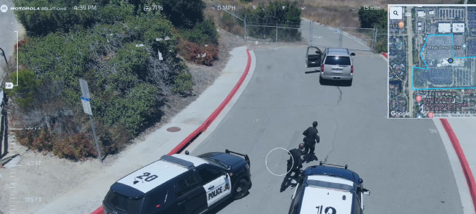
CAPE Command brings full command center capabilities to drone operations with remote flight control, live video streaming, and fleet management tools. Operate drones from a desktop app using keyboard and mouse controls, predefine routes, and access media archives. CAPE Command enhances situational oversight, enabling expert-driven missions directly from the command center.
CAPE’s aerial video solutions transform emergency response with advanced drone technology and purpose-built software. Featuring components for piloting, remote command, and real-time viewing, CAPE enables agencies to enhance situational awareness, improve response times, and streamline evidence capture. From tactical operations to infrastructure monitoring, these versatile tools empower teams to operate safely and efficiently in critical scenarios.
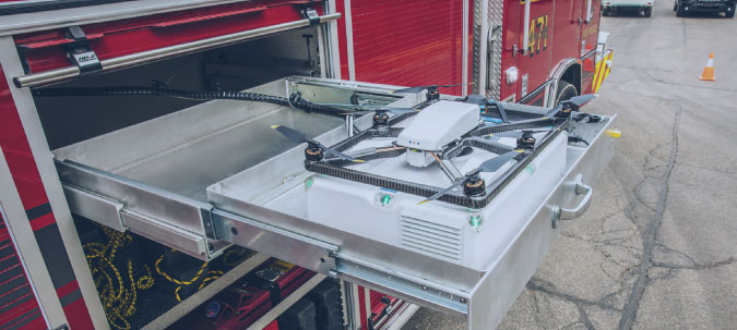
Prepositioned drones provide immediate eyes on the scene before ground units arrive. Upon receiving a 911 call, drones can be rapidly deployed from strategic locations, navigating the fastest and safest routes. Managed remotely via CAPE Command, these drones deliver live HD video, enabling responders to assess situations such as fires or hazardous spills in real-time. This capability allows agencies to deploy appropriate resources faster, enhancing response efficiency and safety.
For high-risk scenarios like serving search warrants, drones act as critical tools for situational awareness. Easily launched on-site, they provide overwatch of inaccessible areas and track fleeing suspects using live-streamed HD video. With telepresence capabilities, command centers can remotely monitor and guide operations, ensuring officer safety while capturing video evidence. This comprehensive view minimizes risk and maximizes operational control during escalating events.
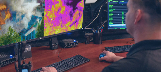
CAPE-equipped drones excel in search and rescue missions, especially in challenging environments like dense forests or rugged terrain. Featuring thermal imaging and real-time location tracking, drones can quickly locate missing persons or suspects by detecting heat signatures. Pilots on the ground and teleoperators at command centers collaborate seamlessly, using live-streamed video to guide rescue teams to precise locations, saving time and lives.
Drones play a vital role in monitoring public safety during large-scale events like protests or sports gatherings. With CAPE Watch, multiple agencies can access live drone feeds, offering a real-time aerial perspective of crowd movements and potential disturbances. This proactive surveillance enables law enforcement to allocate resources effectively, ensuring public safety while maintaining situational control.
When responding to hazmat incidents, drones equipped with specialized sensors can safely assess the spread of dangerous substances. CAPE’s drones relay live data, helping agencies determine evacuation zones and implement containment measures. By minimizing responder exposure, drones enhance safety while providing critical insights for effective risk mitigation.
With telepresence capabilities, drones divide responsibilities between on-scene pilots and remote teleoperators, ensuring optimal control. Remote operators manage camera angles and track movements, such as fleeing suspects, while pilots focus on maintaining line-of-sight control. This collaboration enhances precision and ensures vital evidence is captured and securely streamed to command centers and field teams.
CAPE drones provide essential support for inspecting and protecting critical infrastructure such as power lines, pipelines, and substations. Equipped with high-resolution cameras and thermal imaging, drones can safely assess damage, detect threats, or identify potential failures in remote or hazardous areas. By delivering real-time video and data to command centers, agencies can evaluate risks, coordinate repairs, and respond to security breaches swiftly and efficiently, minimizing downtime and ensuring public safety.
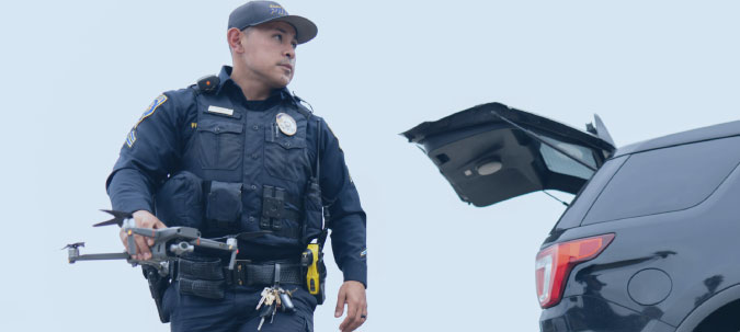
The CAPE Aerial Suite supports only select drones that meet stringent FAA, DoD, and other standards. While MCA does not directly partner with drone manufacturers, our customers should be aware that the drones they use must be "Made in America" and compliant with regulatory requirements to ensure system compatibility. We've featured a few supported devices below designed for secure, reliable operations in critical scenarios. For a full list of supported devices, click the button below.

The BRINC Responder is a purpose-built 911 response drone designed to be the first on scene for public safety emergencies. As part of a complete Drone as First Responder (DFR) solution, it can reach incidents in under 70 seconds, providing immediate aerial intelligence. Key features include a 40x zoom camera, two-way communication, and the ability to deliver life-saving payloads such as AEDs or Narcan. Ideal for de-escalating critical situations, locating missing persons, or identifying fire hotspots, the Responder enhances situational awareness and improves response outcomes for public safety agencies.

The IF800 Tomcat by Inspired Flight is a U.S.-made, medium-lift commercial drone certified under NDAA, Green UAS, and Blue UAS programs, ensuring it meets the highest standards for defense, public safety, and federal applications. With a 54-minute flight time, a 6.6-pound max payload, and compatibility with advanced sensors like LiDAR, EO/IR, and high-resolution optical systems, the IF800 is built for challenging operations. Ideal for tasks such as aerial mapping, search and rescue, infrastructure inspection, and tactical response, this drone delivers reliability and performance in demanding field environments.

Built for demanding operations, the Parrot Anafi USA drone combines cutting-edge imaging capabilities with unmatched durability and security. Engineered and assembled in the USA, it features a 48 MP camera with 4K HDR video, 32-minute flight time, and advanced zoom functionality, capable of capturing 1 cm details from 75 meters. Its IP53-rated design ensures reliability in harsh conditions, while seamless 4G connectivity enables BVLOS (Beyond Visual Line of Sight) operations. Designed with cybersecurity in mind, the Anafi USA includes FIPS 140-2 compliance and no default data sharing, ensuring mission-critical integrity for inspections, mapping, and public safety applications.

The Skydio 2+ (S2+) revolutionizes drone operations with AI-powered autonomy for unmatched 360° obstacle avoidance, GPS-denied navigation, and automated workflows. Compact, lightweight, and equipped with industry-leading NVIDIA compute power, the S2+ ensures safe, precise, and efficient operations for inspection, security, and situational awareness. Designed, assembled, and supported in the USA, it offers unparalleled security and performance. Enhance functionality with Skydio Beacon™ for GPS tracking, 3D Scan™ for high-resolution 3D modeling, and Skydio Cloud for seamless media management.

The Autel EVO II sets the benchmark for versatile and high-performance drone technology, featuring an 8K video camera, advanced obstacle avoidance, and extended flight capabilities. With a maximum flight time of 40 minutes and omnidirectional sensing, the EVO II ensures precision and safety in every operation. Its AI-powered gimbal stabilization and 8x zoom capabilities make it ideal for capturing detailed imagery and videos in diverse environments. Designed for professional-grade applications, this drone offers unparalleled performance and adaptability, backed by seamless integration with the Autel Explorer app for enhanced mission control and data management.

The DJI Mavic 2 Pro combines professional-grade imaging with advanced flight capabilities, making it a top choice for aerial operations. Featuring a 1-inch CMOS sensor and 20 MP resolution, the Mavic 2 Pro delivers stunning 4K HDR video and sharp stills. Its omnidirectional obstacle sensing ensures safe navigation, while a max flight time of 31 minutes enables extended missions. With OcuSync 2.0 technology, pilots enjoy real-time 1080p video transmission up to 8 km. Compact, foldable, and robust, the Mavic 2 Pro is a versatile solution for applications requiring precision, reliability, and ease of operation.
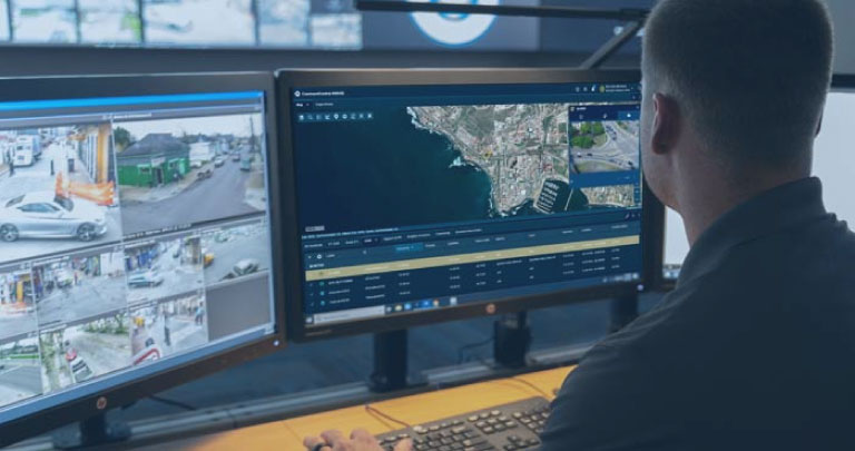
MCA’s integration of CommandCentral Aware (CCA) with CAPE drone software revolutionizes situational awareness for emergency response. By combining CAPE’s advanced drone piloting, livestreaming, and evidence management with CCA’s unified operational view, agencies gain unmatched real-time visibility. Track live drone locations, view video feeds alongside other critical resources, and trigger workflows directly from drone events. This seamless integration enhances decision-making, coordinates responses, and improves incident reviews, empowering teams to respond effectively and safely.

MCA’s Drone Management-as-a-Service, part of our comprehensive MTaaS offering, provides flexible solutions for every level of drone operation. Designed to support tactical missions and advanced drone-as-a-first-responder programs, our tiered plans adapt to your specific needs. The Standard Plan offers essential features like on-scene piloting, 3D obstacle avoidance, HD livestreaming, and cloud video management. The Plus Plan adds remote telepresence for visual line-of-sight operations, while the Premium Plan enables beyond-visual-line-of-sight control and advanced mission readiness.
Choose MCA as your trusted partner for aerial device management solutions that enhance safety, transparency, and operational efficiency. With over three decades of experience and a strong partnerships with the team over at Motorola Solutions, we provide advanced systems, seamless integration, and reliable support to keep your drones flying and your community protected.

Security threats are evolving. Is your facility’s protection evolving with them?
From AI-powered surveillance and access control to concealed weapon detection and cloud-based video backup, today’s security landscape demands more than just cameras and locks—it requires integration, automation, and insight.
This quick 20-Point Security Audit helps you evaluate your current systems, uncover hidden vulnerabilities, and identify opportunities for improvement.
Fill out the form below to download the checklist and discover how MCA’s integrated security ecosystems can:
Whether you’re attending GSX or evaluating your next phase of facility protection, MCA is your trusted advisor in next-gen security.